
Pacific warm-water wave points to possible El Niño later this year
A sea level satellite has tracked a Kelvin wave reaching South America, a pattern NASA says often comes before El Niño conditions.
By Tom Brennan · Health & Medicine Correspondent
3 min read
NASA and European mission partners are watching a broad surge of warm Pacific water that may mark the early stages of El Niño later this year. The observation matters because El Niño can shift storm tracks and rainfall patterns, with effects on farming, transportation, water supplies and national economies, according to NASA’s Jet Propulsion Laboratory.
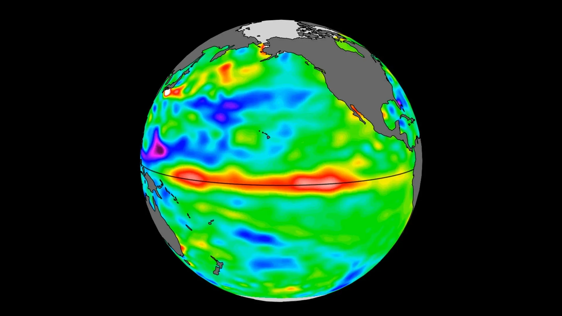
JPL said the Sentinel-6 Michael Freilich satellite detected the warm-water pulse moving east across the equatorial Pacific and arriving off South America in May. The feature is a Kelvin wave, a large ocean wave that can raise sea levels as warmer water expands beneath the surface, according to the laboratory.
What the satellite saw
Sentinel-6 Michael Freilich measures ocean height worldwide every 10 days, with precision to fractions of an inch, according to JPL. The spacecraft, launched in 2020 by NASA and led by the European Space Agency for the European Union’s Copernicus Programme, is used to track sea level changes tied to warming waters.
NASA said a smaller Kelvin wave appeared near Micronesia in late January and faded by mid-February. A second wave formed in early March and continued east, with sea levels near Peru more than 5.9 inches, or 15 centimeters, above long-term averages by mid-May, according to the agency.
Kelvin waves often begin when wind patterns in the far western equatorial Pacific briefly switch, JPL said. Westerly winds replace the usual east-to-west flow, while broader easterly winds along the equator weaken, allowing warm tropical water in the western Pacific to pile up and move east over several weeks.
Josh Willis, a sea level researcher at JPL and project scientist for Sentinel-6 Michael Freilich, said this year’s event began later than the major El Niños of 2015 and 1997 but is starting to gain ground. Willis said scientists will be watching to see how large it becomes.
Possible weather effects
El Niño develops when repeated Kelvin waves over several months help warm water build along the coasts of Colombia, Ecuador and Peru, according to JPL. NASA said El Niño events usually peak from November through January, so the strength and reach of this year’s event will take more time to judge.
Warmer sea surface temperatures in the central and eastern Pacific can alter atmospheric circulation, including the jet stream, according to JPL. That can leave some regions wetter than usual and others hotter and drier.
JPL said moderate El Niño events that began in 2018 and 2023 brought drought and flooding mainly in and near the tropical Pacific. Stronger events, including the 2015-16 El Niño, had wider effects, including drought in Africa and flooding in California, according to the laboratory.
Severine Fournier, a JPL sea level researcher and deputy project scientist for Sentinel-6 Michael Freilich, said each El Niño differs, but the events nearly always bring a hot year and major rainfall changes in parts of the world.
A long-running sea level record
NASA said Sentinel-6 Michael Freilich is the current reference satellite for global sea level measurements. The mission extends a record that began with TOPEX/Poseidon in 1992.
The next spacecraft in the series, Sentinel-6B, launched in November 2025 and is expected to take over the mission by the end of 2026, according to JPL. The Sentinel-6/Jason-CS mission is run through a partnership involving ESA, EUMETSAT, NASA, NOAA, the European Commission and France’s CNES.
This story draws on original reporting from ScienceDaily.