
Satellites track undersea eruption that could form a new island
An eruption north of Papua New Guinea is sending steam, ash and pumice to the surface as scientists watch for new land.
By Priya Raghavan · Science Reporter
3 min read
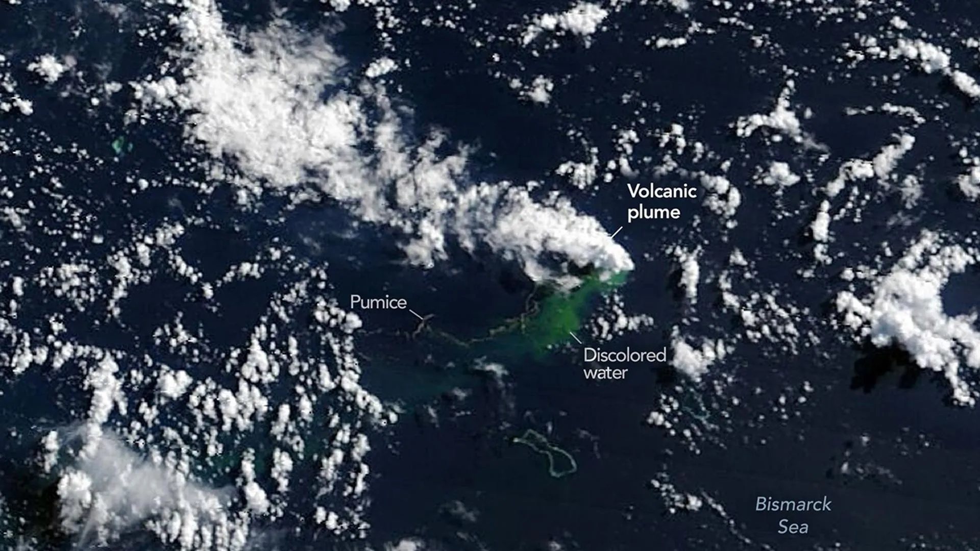
An underwater volcano in the Bismarck Sea north of Papua New Guinea is erupting, and satellites are tracking signs that it may be building toward the ocean surface. The eruption gives scientists a rare chance to watch new land form in a poorly mapped part of Earth’s seafloor, according to NASA Earth Observatory.
NASA Earth Observatory said the activity was first flagged on May 8, 2026, when seismometers recorded a small cluster of earthquakes in the Central Bismarck Sea. Researchers think the eruption is taking place along Titan Ridge, about 16 kilometers, or 10 miles, southeast of a submarine eruption recorded in 1972.
Scientists still do not know which volcanic feature is erupting, how deep the vent was when the activity began, or when that feature last erupted, NASA Earth Observatory reported. The basin contains faults, volcanic structures, rifts, scarps, subduction zones and spreading zones, but much of its deep seafloor remains difficult to map with detail.
“The good news is that there are huge opportunities to explore and learn using both government and commercial satellite platforms already in orbit,” said Jim Garvin, chief scientist at NASA’s Goddard Space Flight Center.
Images show heat, ash and pumice
NASA’s Aqua and Terra satellites began seeing white, steam-rich volcanic plumes on May 9, NASA Earth Observatory said. The PACE satellite’s ocean color sensor also detected broad areas of disturbed and discolored water around the eruption site.
Other satellites later observed ash rising several kilometers into the air. The European Space Agency’s Sentinel-2 satellite and NASA/USGS Landsat 9 collected higher-resolution views on May 10 and 11, while the VIIRS instrument aboard Suomi NPP detected thermal anomalies covering about seven square kilometers on May 12, according to NASA Earth Observatory.
Simon Carn, a volcanologist at Michigan Tech, said the heat signature points to activity close to the ocean surface. “There must be a lot of hot material near the surface to generate so many thermal anomalies,” Carn said. “This suggests a fairly shallow eruption vent -- much shallower than what’s implied by the existing bathymetry, which shows water depths of several hundred meters or more.”
Satellite imagery has also shown floating pumice, steam and ash vents, and plumes of greenish, discolored water. NASA Earth Observatory said government and commercial satellites have followed pumice rafts as currents draw them into long bands across the sea surface.
Scientists watch for new land
Garvin said researchers are waiting to see whether the eruption breaks the surface and creates an island. If land appears, scientists will monitor whether it forms a tuff cone with a lasting crater, collapses quickly, or erodes away.
NASA Earth Observatory said the eruption has so far been less explosive than the 2022 Hunga Tonga-Hunga Ha’apai eruption and the 2021 Fukutoku-Okanoba eruption. Carn said a major escalation appears less likely because this activity is tied to a volcanic ridge near a transform fault and a back-arc spreading center, where eruptions tend to be less explosive than those at large stratovolcanoes along subduction zones.
The duration remains uncertain. NASA Earth Observatory noted that a nearby submarine eruption in 1972 lasted four days, while an eruption about 100 kilometers away in the St. Andrew Strait continued for nearly four years after starting in 1957.
Garvin plans to use radar data from the NASA-ISRO NISAR satellite and the Canadian Space Agency’s RADARSAT Constellation Mission if new land rises above the water. NASA Earth Observatory said researchers could then track changes in the island’s shape, erosion, chemical weathering, rainfall effects, and the arrival of plants and animals.
This story draws on original reporting from ScienceDaily.