
Mediterranean records exceptional June sea surface heat
ESA imagery shows Mediterranean waters up to 8C above the 1991-2020 average as Copernicus reports new June global sea surface highs.
By Tom Brennan · Health & Medicine Correspondent
2 min read
The Mediterranean Sea set a June surface heat record, with satellite-based data showing broad warm anomalies across the basin, according to the European Space Agency. The finding sits within a wider ocean heat signal that the European Union’s Copernicus Earth observation program says has pushed global sea surface temperatures past the June records set in 2023 and 2024.
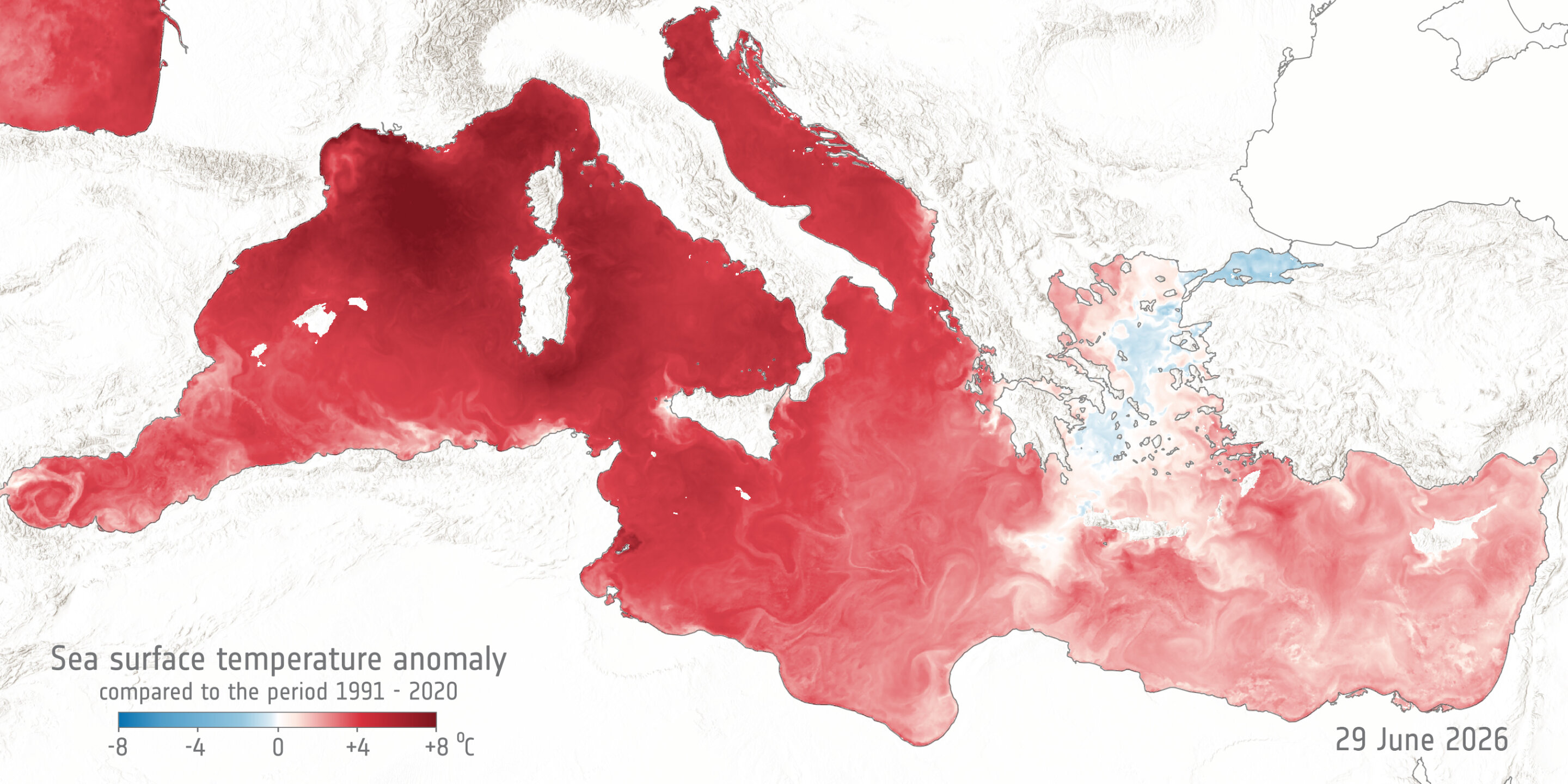
ESA said an image for June 29, 2026, shows sea surface temperature differences across the Mediterranean compared with the 1991-2020 average. In the map, the strongest anomalies are marked in dark red and show waters up to 8C above that baseline, according to ESA.
The largest average increases appear off the coast of southern France, around Corsica and Sardinia, and around the Italian Peninsula, ESA said. Those areas stand out in the June 29 data as the basin experienced record surface warmth for the month.
ESA said the image uses high-resolution sea surface temperature data from the Copernicus Marine Service, known as CMEMS. The comparison baseline comes from a satellite-derived dataset produced by ESA’s Climate Change Initiative, covering the 1991-2020 period.
Copernicus also reported that the global average sea surface temperature has exceeded the June records registered in 2023 and 2024, according to ESA. Copernicus identified Sunday, June 21, as the day when global sea surface temperatures moved above previous daily averages for the same period.
On that date, global sea surface temperatures reached 21C, Copernicus said. That was 0.1C higher than the previous records, according to the program.
The measurements come from satellite and marine monitoring systems used to track ocean conditions across regions and over time. ESA said the Mediterranean image was built from Copernicus Marine Service data for a single day and compared with the longer-term satellite record to show where current surface waters differed most from the recent climate average.
The Mediterranean hot spots identified by ESA were concentrated in the western and central parts of the basin. The map also showed elevated temperatures around the Italian Peninsula, underscoring how the June anomaly extended across multiple coastal and island regions.
This story draws on original reporting from Phys.org.