
New images show Shackleton’s last ship on Labrador Sea floor
The Royal Canadian Geographic Society released the first wreck images of Quest, showing damage from fishing gear and a growing marine habitat.
By James Whitfield · Staff Writer
3 min read
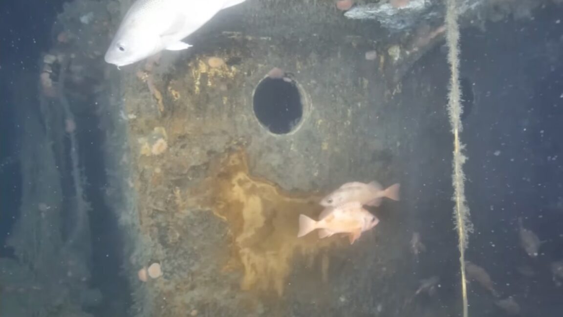
The first images of the wreck of Quest, the vessel tied to Ernest Shackleton’s final expedition, have been released more than six decades after the ship sank. The Royal Canadian Geographic Society said the new survey shows the Labrador Sea wreck is more damaged than sonar first suggested, while also serving as habitat for marine life.
Canadian Geographic published the images from the latest expedition, which was conducted with the Woods Hole Oceanographic Institution. The team used a Falcon remotely operated vehicle and the ALVIN deep submergence vehicle after launching the mission on July 2, according to Canadian Geographic.
Quest is best known as the ship Shackleton used for the Shackleton-Rowett Expedition, which departed for Antarctica in 1921. Shackleton, already famous for the Endurance expedition, died aboard Quest in 1922 before reaching the planned destination, according to accounts cited by Canadian Geographic.
The ship had begun life as a Norwegian wooden whaler called Foca I before Shackleton bought it. His wife, Emily, renamed it Quest, and the vessel was refitted with equipment for polar work, including a wireless set, scientific gear, photographic equipment and a small aircraft, according to Canadian Geographic.
From polar vessel to wartime service
Shackleton’s final voyage was cut short after his death at South Georgia. Canadian Geographic reported that the official cause recorded was coronary thrombosis, and Shackleton was buried at Grytviken.
Quest continued to work for decades after the expedition. It was used in later expeditions, rescue missions and commercial sealing, and served with the Royal Canadian Navy during World War II as a minesweeper and light cargo vessel, according to Canadian Geographic.
The vessel sank on May 5, 1962, during a sealing trip after ice pierced its hull off Canada’s Atlantic coast, Canadian Geographic reported. As with Endurance, the crew survived.
The Royal Canadian Geographic Society led the 2024 search for the wreck and invested about $365,000 in the project, according to Canadian Geographic. The effort, led by RCGS chief executive John Geiger, involved reviewing logs, navigation records and other documents before a 23-person crew spent hours scanning the seabed with sonar.
After 17 hours of sonar work, Geiger identified a shape on the seafloor that the team concluded was Quest, Canadian Geographic reported. The first sonar views suggested the wreck might be in relatively stable condition.
Fishing gear and new life
The closer inspection changed that view. Canadian Geographic reported that the latest images show fishing nets, floats and other bottom-trawling gear caught across the stern and much of the starboard side.
The expedition also found that the bridge superstructure is gone, though the aluminum bridge remains attached, according to Canadian Geographic. Antoine Normandin, the expedition’s research director, told the magazine he was initially disappointed by the condition but came to see the wreck as “now becoming a science experiment.”
Researchers also found that the wreck has become a reef-like habitat. Woods Hole biologist Kirstin Meyer-Kaiser told Canadian Geographic that soft corals have gathered near the bow, and that species seen at the site include the threatened spotted wolffish.
Meyer-Kaiser told the magazine the ship has created habitat and may be increasing biodiversity around the wreck, and possibly beyond it, by acting as a stepping stone for species to spread.
The images released so far are only the start of the survey work. Canadian Geographic reported that the team plans to use underwater photogrammetry to build a 3D digital model of the wreck site.
This story draws on original reporting from Ars Technica.